
Once in a while, I run across some super useful geological figure or diagram. I ran across this little gem while perusing through a report on the Paleozoic rocks of Minnesota.
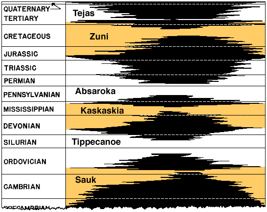
Now, I have strat columns of the Minnesota hanging around, but this isn't a traditional strat column (it's much cooler, oh yes). It shows a number of things which a regular strat column doesn't.
A strat column will show the names, vertical positions/thicknesses, and symbology of each geologic unit. So does this diagram. Where they are differing, though, is that the vertical axis on a strat column is "thickness" while the vertical axis on this diagram is "time".
The first fun thing to point out is that they don't mean the same thing. These are all sedimentary rocks, yes, which take time to deposit, I know, so thicker rock units obviously took more time to form, right? Well, not exactly. One rock unit which formed from rapid deposition over a short period of time may end up being the same thickness as one that formed from slow deposition over a long time. Geology is tricky like that sometimes.
A convenient example of that last point is seen by comparing the Jordan Sandstone and Oneota Dolomite (at the Cambrian/Ordovician boundary). They're almost the same thickness in many places (the Jordan is slightly thinner at about 100 feet, compared to the Oneota's 125-150 feet). But in terms of time of deposition (based on the diagram) the Jordan Sandstone formed more rapidly; only about a million years, compared to the Oneota's five million years. Just doing basic math (forgive me for oversimplifying sedimentation), that means the deposition rates are something like:
Jordan Sandstone - 70-100 feet per million years
Oneota Dolomite - 25-30 feet per million years
Getting to the basics of what these rock types are, this relationship makes perfect sense to me. The Oneota is a carbonate rock formed from marine organisms in gentle, shallow, offshore environments (like the Caribbean). Deposition would be slow, but fairly constant. Carbonates need some pretty hospitable conditions to form, so rates are easily affected if the right conditions aren't met. As for the Jordan Sandstone, formed by the deposition of sand in a near-shore environment (like a beach) by sediment grains being washed in from the highlands, the conditions don't need to be friendly. In fact, the Jordan Sandstone tends to have some fairly thick and pronounced cross-bedding, indicating some large tidal events or storms. Although deposition would not be constant, when it happened, it would be in fairly large bursts.
The second thing I like to notice is how much of time has no rock record (the gaps between rock units). These represent periods of time in which either 1) deposition and rock formation didn't occur, or 2) deposition and rock formation occurred but was then eroded away. This happens when sea level drops and the rocks are exposed to weathering and erosion.
Another thing which finally made a lot of sense upon seeing this diagram (which I wish I could have seen in Sedimentology/Stratigraphy class) were the Cratonic Sequences (or Sloss Sequences) on the right side of the diagram (the Sauk, Tippecanoe, etc), about episodes of deposition and erosion of the Paleozoic rock units in North America. My professor would just show us this eye-sore of a diagram and go "get it?" and we'd go "no". But when I saw this diagram, I saw (because of the vertical axis being time) the "groups" of sedimentary rock units separated by the gaps with no rock record:
1. The seas rise, flooding the continent. The first units to form are formed from eroding the basement rock, making them clastic and sandy (the Mt. Simon (which I've talked about)/Honckley/Fon du Lac Sandstones). Seas rise, shoreline progresses inland, water gets deeper, and then the shaley units form (Eau Claire/Franconia/St. Lawrence Formations). More sea level rise, and finally you get the carbonates (Oneota Dolomite/Shakopee Formation). This is a typical transgressive sequence, something you learn as a first year geology student. More specifically, this is the Sauk Sequence in Minnesota.
2. The seas recede and expose the previously deposited rocks to erosion. These can be short-lived recessions (like between the Oneota Dolomite and Jordan Sandstone) or large (between Sloss Sequences).
3. The seas advance again; first forming the clastic rocks (St. Peter Sandstone) then grading upward through the shaley units (Glenwood Shale, Decorah Shale) and into the carbonates (separately indicated on the diagram, but overall referred to as the Galena Group). This is the Tippecanoe Sequence.
4. Seas recede again for a while, and when they advance again, deposit the Kaskaskia Sequence (which only occurs in a small part of southern Minnesota, so I've never seen it in any well logs yet).
All these sea advances and recessions occurred in Minnesota in what is called the Hollandale Embayment - a depression which allowed the sea to advance "upward" into the otherwise highland of the area. Since Minnesota was fairly high above sea level at the time, only the largest sea advances "reached" us, making the Paleozoic rocks here generally thin and representing short periods of time. This is opposed to, say, Missouri, which was closer to the edge of the continent and therefore developed a much thicker and more complete sequence of sedimentary rocks (while Minnesota's sed-rocks end in the Devonian, Missouri has another 70 million years worth of rock on top spanning through the Mississippian and Pennsylvanian periods, including the 4th Sloss Sequence, the Absaroka Sequence, which is absent in Minnesota). The strat columns of these two states therefore share equivalent rock units at some places; sometimes with the same name (St. Peter Sandstone, Glenwood Shale), sometimes with different names but stratigraphically the same (Mt. Simon Sandstone in MN = Lamotte Sandstone in MO). But Missouri contains many sedimentary rocks that have no Minnesota equivalent, since sea level advances reached Missouri much easier, and stayed longer.
The last thing I wanted to talk about which related to what I do for work is in regards to the gap between the Oneota Dolomite and Shakopee Formation. For almost all purposes, these two units are usually just grouped together into what is called the Prairie du Chien Group - both because they look so similar in well logs, but also because there's "usually" no sense dividing them as they tend to behave as one hydrogeologic unit. But we have observed an exception - during that gap between the units, the Oneota Dolomite was exposed to the land surface, resulting in karst formation, which was then advanced over to form the Shakopee Formation. When we've looked at this boundary in downhole camera video and depth-specific sampling, we can see this paleokarst boundary as small caverns and sand. This boundary acts as a groundwater conduit which we've seen increased water flow and even different water chemistry.