Wednesday, April 8, 2015

Thawing Thalweg

Winter is finally turning to spring Minnesota, and things are melting! My neighborhood's major riverway, Minnehaha Creek, is starting to thaw. I had a day off the other week, so I decided to go for a walk around the creek, which is when I noticed something interesting - it's thawing in a very particular way that crazy river people would notice and get a little too excited about. See if you can spot it:


You might notice there is open water on either one bank or the other, which is correct - the ice seems to be melting along certain parts of the stream. This might not seem very significant, but it is! Like most things geological, the fun part is learning "why."


Water flows down stream channels, which aren't often very straight [citation needed]. When the water reaches a meander or bend in the stream, physics steps, and a few important things begin to happen. 


Firstly, as you can see from the above image, the bank on the outside of the bend is where the incoming water "collides" with the bank, resulting in erosion of the bend (rightfully called the cut bank). As you could imagine, this would cause the outside bend to meander outward even more, creating a sharper bend, which would cause the water to erode the bank even greater, and so on. This is called a positive feedback loop, in which A increases B, and B increases A, which goes on forever until something breaks. Once a bend begins in a river, it will grow until it becomes so big it eventually cuts itself off, usually leaving behind an oxbow lake and other really cool landforms.

Birth and death of a meander bend, resulting in an oxbow lake

Whoever said nobody crosses the same stream twice wasn't kidding

Secondly, if you imagined the mass of water moving through the stream as a group of runners going around a track, in order for everyone to stay in a group, the person on the outside runs faster than the person on the inside of the turn, as they'd have to run a greater distance to keep up. For the stream, this means that the water flowing along the outside of the bend not only hits the bank more directly, but is also moving faster, which also increases erosion. In contrast, water moving around the inside of the bend slows down. A stream's ability to transport sediment is a result of how fast it is flowing, so the inside of a river bend is where a lot of the sediment is deposited (called the point bar), making it shallow. If you're ever in Alaska panning for gold, this is where the flakes are. 

In the end, the different velocities resulting in either deposition or erosion around a river bend means that the channel profile is lopsided. If you were to measure the depth of a river across the channel around a meander bend, it would look like this:

Cross-section of a stream channel. Note the asymmetrical depth of the river.

The deepest part of the river is called the thalweg, which is one of my favorite geo-words. It is due to focused erosion from increased stream velocity and the physics of fluids flowing around a bend. When rivers are used as political boundaries, the thalweg is often used to define that boundary. From the air, the thalweg would be drawn like this:


In fairly straight streams, the thalweg is near the middle of the channel, while in very bendy streams it alternates from one bank to the other. This above diagram (specifically the bendy example) is what came to mind when I saw the preferential melting of Minnehaha Creek - the thalweg of the creek is what is melting first. This makes sense, as the water there would be deeper and faster, and therefore more able to transport heat and melt and carry away the ice. In one of the photos, you can even see the thalweg switch banks from one bend to the other:


First ice melting in Minnehaha Creek is concentrated at the thalweg.

The thalweg meanders along the stream to be closest to the cut bank, evidenced by the melted ice.
I think one of the reasons streams are always so cool is because, geologically speaking, they're very dynamic - that is, they change a lot, and in human lifetimes. They're also scale-able, so you can simulate how large rivers form by looking at small rivers, or even making your own in labs. My undergrad geology department had an Emriver, which is basically a large adjustable sandbox with hoses and dyed water.


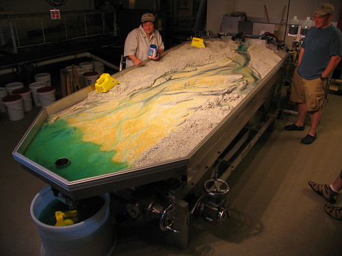
This allowed us to create and destroy our own rivers, and see how changing things like slope and water velocity would reshape the stream. It was always very zen to watch. You can really see the concepts I describe above in action with the formation of cut banks and point bars in this time-lapse video.


Monday, March 30, 2015

Flight over the Driftless(?) Area

Being an enthusiast for both the earth sciences and aviation sciences, I always try to book my flights with a window seat, preferably behind the wing. That way, between watching the ground and the clouds, I get to watch all the flaps and ailerons working on the wing. I never get bored.

On a flight to Philadelphia the other week, I took a few interesting shots of the Mississippi River on the leg from Minneapolis to Chicago. Since it's such a short flight between the two, it didn't seem like we got too high before we had to start making our way down. Getting the chance to take some photos of this area was extra meaningful for me, as it's in the Driftless Area, which is where I first learned to be a geologist and a pilot.

Just out of Minneapolis airspace, eastbound, before we turned southeast. I wanted to get a shot of the Moon above the frozen Lake Pepin.

The formation of Lake Pepin is one of my favorite geology "stories". If you look on a map, the Mississippi River gets very narrow on the downstream side of the lake. This is due to the smaller, sediment-rich Chippewa River flowing into the Mississippi and dropping its sediment, causing a delta. This creates a natural dam, which then backs up the Mississippi River upsteam. This has two interesting effects on the local waterflow.

First, since the water backs up upstream, the river both widens (Lake Pepin) and the velocity drops (Q=VA, A increases, so V decreases). This creates a large, gently flowing area for boaters, which there are plenty of. Lake City is said to be the birthplace of water skiing. Due to the larger body of water, which also flows slower, the lake also remains frozen longer into the spring than the adjacent sections of the river, which has historically affected river boat traffic to the Twin Cities from more southern ports. The city of Reads Landing is so name because this is as far as ferries could go, and would have to land there, then take land routes the rest of the way north.

Secondly, the bottle-necking of the river from the delta causes the stream to narrow and flow faster (again, Q=VA, now the A decreases, increasing the V). This means that the section of the Mississippi River through the delta, in contrast to Lake Pepin, never freezes. This creates the perfect place for bald eagles to hunt for fish in the middle of winter. There are a number of spots along the river to stop and watch some eagles (link here). Thanks to places like these and efforts by groups like the National Eagle Center, the eagle population in this area has grown quite a bit, and has helped bring bald eagles off the threatened species list. I took this route along the river between Minneapolis and Winona countless times as an undergrad, and got to see firsthand the population of eagles in this area slowly increase.


A frozen section of the Mississippi River, southeast of Minneapolis/St. Paul. Note the deeply incised tributary valleys along the river valley.


North of a frozen Lake Pepin, looking south. The Mississippi River widens here due to the channel becoming constricted from an influx of sediment from the Chippewa River forming a delta bottleneck (on the left of the photo). Since the water backs up and slows down, it also stays frozen longer into the spring, delaying riverboat traffic into the Twin Cities above this point.

Flying over western Wisconsin. The incised stream valleys all retained a bit of snow despite the recent warmer weather. So much for being "driftless"(!). 

I zoomed in a bit on one of the rivers below because of all the oxbows. Everybody likes seeing oxbows from the air.

As we made a turn towards Chicago, the Mississippi River started to fall away from us, and I realized I wasn't going to get a chance to take a photo of my old stomping grounds near Winona, which is just out of view along the river.


In contrast/continuation of the above photo, here is one I shot of Winona while flying in to visit during the summer. Also, a bit lower than an airliner!